
Lola Montez Lakes
-
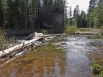
- The stream fording
-
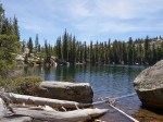
- Lower Lola Montez Lake
-
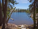
- Lower Lola Montez Lake
Lola Montez Lakes (medium, out-and-back, map, track). One-way length: 3.4 miles. One-way elevation gain: 776 ft, loss: 329 ft; total elevation gain: 1,105 ft.
Lola Montez Lakes are two beautiful lakes set in a mix of granite and forest. This is an easy hike, that follows dirt roads for two-thirds of the way, and footpaths for the final third. There is a torrent to ford along the way, and this can be deep in the Spring; better do this hike later in the season, or carry walking sticks to help in the fording.
The trailhead is reached from the Soda Springs exit on Hw 80. Go to the North side of the exit overpass, and take the ramp to the right that leads in 300ft or so to a fire station. Drive past the fire station; the trailhead is some 1000 ft ahead, indicated by a sign on the left side (the North side) of that road.
The trail follows first a footpath, joining then a dirt road (turn right onto the dirt road). After passing a small hill, the road descends to the stream fording. After fording the stream, the road will take you over another small hill, and past another, much smaller, stream. Do not take the dirt road climbing to the right immediately after this second stream; it leads to private property. Rather, continue for another 300 ft or so, and take a right onto a footpath marked by a sign.
This footpath zig-zags in the forest, gaining elevation, until it reaches a second dirt road. Take it to the right. You will come across several forks in the road: follow the main road, or the signs for Lola Montez Lakes, or use the GPS track provided to help you in the navigation.
After some time, you will veer to the right, taking a path that enters National Forest land. The path will soon lead you to a meadow. After crossing a small stream in the meadow, take a path to the left that will take you in a few minutes to the lower lake.
The upper lake is reachable via a cross-country walk mixed with occasional scrambling over rocks. Go to the far end of the lower lake, and scramble up to the right, gaining the first 100ft or so of elevation; look for cairns that mark the unofficial path. Then, turn a bit to the left, and continue climbing. You will pass some very panoramic expanses of granite, which offer a very wide view over Donner Pass, Castle Peak, and the mountains of Sugar Bowl. The upper lake is very picturesque, even more so than the lower lake.


You must be logged in to post a comment.